Thursday, December 3, 2009
Pedestrian Modeling Overview
In the past, there has been a large amount of work done to model pedestrians for various systems. For the many applications, such as urban planning, construction of high pedestrian density buildings such as rail stations, there are naturally many forms that pedestrian modelling can take. This article lists and describes many different types of pedestrian modeling including the cellular automata and agent-based approaches that we are taking in this project. Though slightly dated, it provides a good foundation for understanding the work that has already been completed in this field.
Thursday, November 19, 2009
Combining cellular automata and intelligent agents

Movement, PEDFLOW: Development of an Autonomous Agent Model of Pedestrian Flow) use a cellular automata system to model pedestrian traffic and overlay that with an intelligent agent system for when the pedestrians have options for where they can move. A cellular automata system is basically a set of rules that dictate for each pedestrian in the model what they should do in the next time step based on their current state. The state of a pedestrian is a combination of their location, individual characteristics of that pedestrian such as how much personal space they like to keep between themselves and others, and the portion of the outside world that that pedestrian can "see." We are going to try to use something like this in our model.
Friday, November 6, 2009
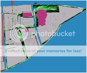
Presentation on Current Progress and Methodology
For the past two weeks, we have been finalizing our practical methodology and gathering data from the various areas of study as outlined in our proposal. Today we presented some slides to Prof. Gibson that detail our progress thus far. It also includes our methodology that has been revised from our work in the field and from consultation with Fabio Carerra and the rest of the VPC staff. Below is an example of some of the material presented, a map detailing the locations of the bridges that we have started to study.

The green circles are our highest priority bridges, the pink squares are the secondary bridges.
The full set of slides is available for download here.
The full set of slides is available for download here.
Wednesday, October 28, 2009
Salute Evacuation Model
We have arrived in Venice! While our team becomes acclimated to the new environment, we would like to share a portion of our previous work.
One of the primary reasons for studying pedestrian traffic is to get an idea on how pedestrians would behave in an evacuation scenario, so policies can be put in place by city officials to manage crises as efficiently and safely as possible.
Using code from a previous IQP, who examined mostly boat movement, we have put together a rough simulation of an evacuation of the area around the Salute church during the Nov 21 Festa della Salute.
There is a video here, and our code can be found here.
Friday, October 16, 2009
Venetian Mobility: Modeling Movement by Land and Sea

We would also like to acknowledge several individuals for their help in the creation of this proposal:
Fabio Carrera
Daniel Gibson
Stephen Guerin
Simon Mehalek
Andrea Mancuso
Christine Friese
Oljora Rezhdo
Moving forward, we are excitedly approaching our arrival in Venice and preparing accordingly.
Saturday, October 10, 2009
The Feast-day of the Madonna della Salute
"The Festa della Salute is probably the least "touristy" of the Venetian festivities and evokes strong religious feelings among the city's inhabitants.
The holiday is, like the Redentore, in memory of another bout of pestilence, which lasted for two years from 1630-31, and the subsequent vow by the Doge to obtain the intercession of the Virgin Mary.
Even today, thousands of inhabitants visit the main altar of the imposing Salute Church on November 21 to give thanks, and a strong symbolic tie remains between the city and the Virgin Mary."
For our project, this event will give us a valuable opportunity to examine the behavior of pedestrians in large densely packed crowds. Not only will we be able to use this data as a comparison point for our pedestrian model, but we can also use this event as a focus point for a model simulation of an evacuation event. A map containing the location of the temporary bridge is here.
View Salute Event in a larger map
Thursday, October 1, 2009
Vaporetti Map

The city of Venice has a public transportation system that consists of "water buses" or vaporetti that move around the city by a set network of stops, as seen on the right. These traverse the city and also go to Marco Polo Airport, Lido, and Murano, among other key locations.
Subscribe to:
Posts (Atom)